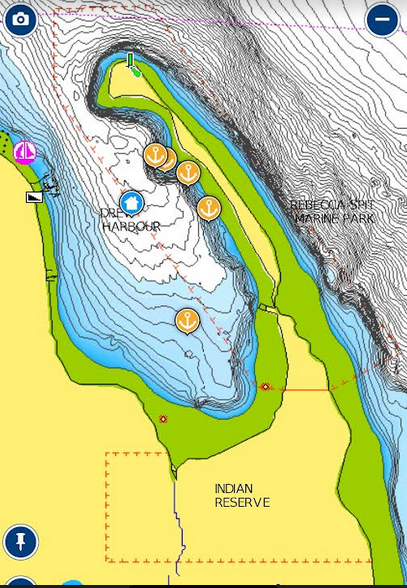
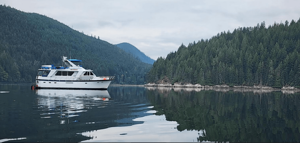
After a long haul North from Tribune Bay, Hornsby Island, we landed and stayed in Drew Bay on Quadra Island. Our anchorage, just off Rebecca Spit was fetching. The little white house icon on the chart photo, is where we were anchored. The entire Bay is surrounded by fairly steep gravel beach littered with driftwood. The water gets deep quickly. The middle of the bay’s bottom is flatish with lots of thick sedimentary mud, and varies in depth between 60 and 100 feet. We were anchored in 60 feet. Too deep for some but comfortable for Great Northern.
As you can see below, the spit is a long gravel arm reaching out from Quadra Island. At its base is a First Nations Reserve. Extending out from there the arm points to the Northwest. So… winds from the Northwest can be problematic. Winds from most other quadrants are mostly manageable. Just put out more chain.
The middle of the Spit it is forested with the usual: Doug fir, cedar, the odd spruce and hemlock, madrona, salal, huckleberry, Oregon grape, squirrels and lots of birds. There is a very nice trail down the middle and around the end.
After being cooped up on the boat for several days, Leo found the trail to be a welcome playground where he got to be off leash for a bit. The smells, bushes, birds, chittering squirrels, bees buzzing about… a magical place for an emancipated dog. His routine on a walk is to stop and start smelling a bush. He puts on this inward look as he assesses what has passed and touched the bush: other dogs, people, birds, squirrels, insects. He’ll stick with the bush as we amble up the trail, inhaling it’s wonders. When we get 20 to 40 feet away, he looks up and runs up to and past us about 6 feet, stands and looks important, scanning his territory ahead for another interesting thing to sniff. It’s fun to watch him in a place where he can do that.
Having a campground and small boat launch nearby, there were other homo sapiens lurking about, not just us. Everyone seemed quite low key or at least putting on that impression. It appeared that loafing was expected. Drew Harbor and Rebecca Spit are made for loafing. So… like everyone else anchored in the Bay, ensconced in the campground, sitting on the beach amongst the driftwood, ambling on the trail… they did all that with an attitude that exuded loafing. So… we loafed around in Drew Bay for several days. When in Rome…
Dinghy rides, walks on the spit with Leo padding along beside, behind, ahead, between and around us. SUP paddling, napping, replenishing stores at the Heriot Bay store, sipping wine at sunset and cogitating… an important function. There’s a lot to absorb and store while traveling and exploring new places. That rip rap you’ve stashed in your mind about the experiences have to be sorted. Teasing through it all is an interesting process. Most of it automatic. Some of it conscious effort. What to absorb? What to keep? What to toss. Determining how the end result of the cogitation will impact what to plan for next.
We were in the midst of developing a meaningful cruise itinerary. A work in progress… It always is. We are not big planners. Both of us have done enough planning… For the most part, we just make an attempt to move forward. One step after another…
Loosely speaking: Our “plans” included leaving Ludlow, traveling through the San Juans, and Gulf Islands. Making our way through Nanaimo, up to the Discovery Archipelago, Desolation Sound. Then down the Eastern shore of the Strait of Georgia, visiting new and already explored areas on the Eastern shore. Somewhere we will check back into the States and make our way back to Ludlow. There is no hurry. Stay another day? Why not… We do have one important stop to make / place to visit before we make the final turn to Ludlow: Oak Harbor. There we will be able to meet two important cruising needs: refueling… and Les, who needs a haircut. Then it’s back to Ludlow to get ready for our next escapade.
We departed Drew in the morning of 8/28/23. Our plan was to travel Northwest up Hoskyn Channel and then enter Okisollo Channel, through Surge Narrows, the gateway to the Octopus Islands and Waiatt Harbor. Magical places we’d read about. The course took us 13.3 nautical miles (NM) Northwest of Drew. Along the course, we would face several navigational obstacles. The first at NM 8.4: Narrow Beazley Passage and the notorious Tusko Rock (named after someone who most likely discovered it by running into it…) I’m sure that somewhere in an inter-island newspaper article in the musty stacks… that it was reported. Such things were… First Nation tribes have known about that rock and most of the others that matter… for millennia.
After passing Tusko Rock to starboard, we would transit the lively and aptly named Surge Narrows. We found durind our transit… that after getting thriugh Beazley Passage, Surge Narrows was a breeze. Our final and most noteworthy hurdle: Wending our way through a narrow, rock strewn channel, passing the Octopus Islands to starboard into our final anchorage: Waiatt Harbor. It was a 13.3 NM adventure… A dance in the park for some… a white knuckled experience for others. For me… the first time I traverse a tricky navigational challenge, I tend towards the white knuckle, fight or flight related experience, attenuated with as much data that I can collect from multiple sources… The second time: A dance in the park.
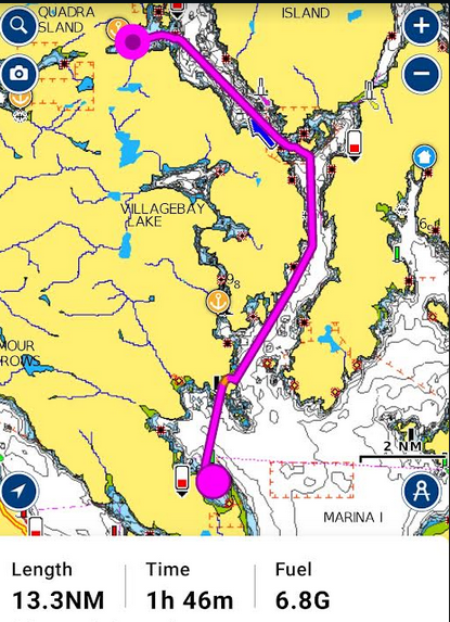
I set two courses. One from Drew Harbor to Beazley Passage and another from Beazley Passage to Waiatt Harbor. I wanted to know exactly when we were at the mouth of Beazley passage.
The first course, Beazley Passage was up on the plotter and set and the autopilot was steering as we left Drew. The plotter displays distance to each waypoint, total distance to Beazley and more importantly: the time remaining to make it to the end or the route. That is displayed on the plotter as estimated Time To Destination (TTD). With courses set, motors running, all systems go, we made our way Northeast up the wide and calm Hoskyn Channel.
There are places in the Discovery Island archipelago, where the currents can reach 16 knots. The whirlpools created, massive overfalls, and rough rapids can become an existential experience… even for a boat our size. Beazley Passage between Sturt Island and Peck Island can be such a place.

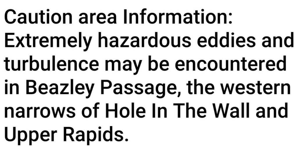
The descriptors: Extremely, hazardous, turbulence should make an impact on most mariners. Data points to consider: On 8/28/23, the time of slack water at Beazley Passage was to occur at 15:41, a bit further along, Surge Narrows would be slack at 15:55. There is a reason to be careful. At 12:00 on the 23rd, the water would be flowing through the Passage at 9.1 knots… against us. Tumultuous at the very least. At 17:48, a couple of hours after we were scheduled to pass through what can be a broiling miasma, the water would be churning along at 6.2 knots. An aside: It is important to pay attention to and understand the current flow in the Discovery Islands, Desolation Sound, and anywhere for that matter. It is always best to seek out the times within 10 to 15 minutes of slack while the current is trying to change from ebb to flood… or flood to ebb. During those golden minutes of slack. Rapids, tight channels, and passages can be transited in safety and with aplomb.
Also, on the chart above, in addition to the exclamation mark and the little black squares with reddish dot borders, are rocks to be wary of and and give a wide berth to. We planned our course and transit times accordingly. To employ the Simrad chart plotters to our best advantage, I used the Time To Destination feature to adjust boat speed being affected by currents and wind… so the time to our destination always read 15.41.
We arrived at Beazley Passage at 15:42. Just before the opening to the Passage, we came upon a slow moving sailboat, Elysian. We contacted their captain on channel 16, slowed down for, and passed them to starboard with their permission. We then went through Beazley 1 minute late… The slack waters were fairly placid. Under control. And… invigorating: To have the tools, understand how to use them and keep our vessel home and its occupants safe.

Next up and really just a continuation of Beazley Passage is Surge Narrows. A delightful name. Note that the notorious Tusko Rock occupies it’s clutching granite arms there, at the end of Beazley Passage. The current in the passage is set to push you towards it’s cold and clutching arms if you let it. Best to stay alert, eh?

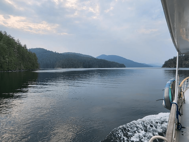
After motoring a few more miles we arrived at the Southern, rock strewn entrance to the Octopus Islands, and slowly cruised through those obstacles to reach our final destination: Waiatt Bay:

Once inside the calm vastness of Waiatt…we anchored and put the engines and electronics to bed. We made a few gin and tonics with a twist, and sat on the bow deck chairs to review the resplendent scenery of our new domicile, and celebrate our successful voyage.
That is enough to ponder for now, eh? We are in Gorge Harbour just now and have reasonable cell coverage. For the next little bit, coverage will be sparse. Later today I’ll put together pictures of Waiatt Bay and the Octopus Islands. Not much discussion. Just eye candy…
…Blair
